unpublished ...
Rocque Map Article
Part II
by Jack Redmond
[The following note was included with copies circulated by the author.]
The first part of this article was published in Vol. 6, No. 2, 1990-1991. At the last minute before printing this article was divided in two. In the adjustments to suit printing the key to figures 3 and 4 was omitted. It is now included here, on a separate slip to be inserted edgewise under the centre fold and between the securing rivets of the magazine. I suggest to face p.37. This is for the one or two only private copies intended for selected people, pending publication of the second half in the next issue. Illustrations 8 A, B, C etc., in these private copies will be put on their own sheet, in photocopy form and shaped and cut for best clarity. The "Review" printers have already prepared these in computer file in their original framing in a manner suited for printing. The Portadown town/area map was also left out, but was inserted into each copy in photocopy form before distribution. Please now read on...
Part 2.
In my area he omits the North East leg of the Loughgall ring, the piece above the courthouse. He shows a direct road from Ardress to Tullyroan which was never built, being shown only as "intended road" by John Rocque some 40 years earlier. He omits the newer straight link from Portadown to the Birches, yet this had been shown on Taylor and Skinner's attractive main road, through-route, strip maps book of Ireland some 20 years earlier ! (He actually proves this omission on "his" second map, the Lough Neagh one, to which we shall come presently, which includes the Birches link !).
But let us return to his first map.... he misnames Richmount, near the present Scotch St. filling station, as Richhill, and simply disappears the village of that name. He translates the river Tall from its valley between the Diamond and Crowhill (close by my home) to a line nearly a mile to the South of its course, so that it no longer passes under the Cushenny road at Cushenny Bridge, rendering that bridge redundant. The road over the Diamond Hill towards Crowhill has been spirited away. Since he has stolen the road and moved the river, he has also made away with our Redmond's Bridge, a very serious offence.
Sir Charles' crowning achievement was the re-unification of Derrywarragh Head with the mainland at Maghery, by the clever expedient of removing the canal which separated them then, and indeed still does.
Fortunately for all concerned the 1832/35 surveyors put everything back the way Rocque had shown it in 1760.
His second map is of Lough Neagh and an area around it. He does not say it is his own work, but equally does not mention any author. However, the blank patches in the top corner area, combined with the centre panel giving data on the tidal effect of the wind in 1785, together with other features clearly betray his Lough map as a smartened up and enhanced version of "D 604", Lough Neagh and environs of 1785, in the P.R.O. in Belfast. The blank corner of his sheet replaces exactly the other data panels of "D 604" which of course obliterate roads and houses there.
Here arises a point of interest which calls for research by some enquiring mind.... both Dr. Beaufort in 1792 and Sir Charles in 1804 refer to "Mr Lendrick's map of Lough Neagh and environs of 1785". I am tempted to believe that "D 604", whose author's name is not filled in, is in fact Mr Lendrick's work. Yet Sir Charles says that Lendrick sums the Lough area as 58,200 acres, while "his own" map gives 60,361 acres as does "D 604".
If both maps are by Lendrick, someone has re-estimated the area. Either way, Coote cribbed again, and his credentials as a cartographic critic have crumbled.
Rocque does manage to triumph over his critics. But now we must tread more warily, for the next critic is the formidable Professor Andrews. He obviously knows the whole map business thoroughly, and has carried out very extensive original research, setting out his conclusions in classic and unambiguous English and scientific precision. Fortunately ( or perhaps unfortunately ?) he has not yet published a detailed survey of John Rocque's Armagh, so I am free to have my own opinion on debatable issues.
The Professor takes the view that Rocque was labouring under a handicap when working to a scale of 12 inches to the mile (Eng) for the Armagh map, and speaks of an element of deception in portraying fictitious hedgerows and fields, and in pretending the whole was a mosaic of small farm maps.
He also simply repeats what Sir Charles said about the map being criticised from within the county, before the Grand Jury decided to replace it in the late 1770's. But, as I have shown, this was more a matter of updating than of correction or improvement.
I do not have to agree that the fields apparently drawn were meant to portray real fields, any more than I believe his windmills were, as it were, photographs of the real thing. The Armagh windmill seen in the painting in the County museum shows the rebuilt one of 1810. The grave slabs in some of the churchyards could not portray the real thing. Nor could the round hills represent flat topped circular mounds. His plough furrow symbols patently do not represent individual furrows, the little lines of dots only suggest the plough. I believe John Rocque simply indicated to the traveller with his symbols that in an area these were the conditions one might see.
Leases of that time instruct tenants very exactly to plant thorn quicks at close intervals interspersed with forest trees at longer spacing around their farms. This John Rocque clearly illustrates on his road sides. But I am certain that he was of sufficient intelligence to realise that any attempt to deceive local buyers about imaginary farms and imaginary fields would be instantly detected, so I cannot support the deception theory.
Fig 7. - Accuracy Check
| 1 | 2 | 3 | 4 | 5 | 6 | |
| Portadown-Maghery Bridges | 8.07 | 20.35 | 20.50 | -0.15 | -0.73 | +1.33 |
| Portadown-Poyntzpass canal Bridges | 9.52 | 24.2 | 24.2 | 00 | 00 | +2.06 |
| Poyntzpass Bridge-Markethill (St. junction) | 6.04 | 15.1 | 15.35 | -0.25 | -1.62 | +0.44 |
| Markethill junction-Portadown bridge | 9.84 | 23.3 | 25.0 | -0.17 | -0.68 | +1.38 |
| Markethill junction-Armagh Rd. junction | 6.18 | 14.95 | 15.7 | -0.75 | -4.7 | -2.64 |
| Armagh Rd. junction.-Loughgall Courthouse | 4.88 | 11.82 | 12.4 | -0.58 | -4.67 | -2.61 |
| Loughgall Courthouse-Portadown Bridge | 6.53 | 16.5 | 16.6 | -0.10 | -0.6 | 1.46 |
| Loughgall Courthouse-Richhill centre | 3.34 | 8.07 | 8.5 | -0.43 | -5.06 | -3.0 |
| Tandragee St. junction -Loughgall Courthouse | 8.38 | 21.18 | 21.3 | -0.12 | -0.56 | +1.5 |
| Average error in Rocque distances,%, on copies used = "scale error" | -2.06 | |||||
| Average of errors corrected for 2.06% bias in scales used ... in % ... plus/minus | 1.82% | |||||
Worst limits of errors in small sample used: -3% and + 2% approx.
Key
- Column 1 shows approximate scaled distances measured in miles
- Column 2 shows distances measured in centimetres between fixed landmarks visible then and now, taken on a reduced scale 1"/mile copy of John Rocque's map.
- Column 3 is for the same taken on a 1" O.S. map.
- Column 4 gives the difference in centimetres, and
- Column 5 gives this difference in % terms.
- Column 6 shows this last corrected for scale error.
This table does not necessarily represent academical statistical methods, but does give a reasonable indication of John Rocque's town-to-town accuracy. The 1" map copy used was slightly off-scale in copying, as was J.R's map.
On 10 miles, a 3% error represents 528 yds, or 264 yds on 5 miles. A 1% error would mean 176 yds for 10 miles, and 88 yds for 5 miles.
Professor Andrews wrote these fairly mild comments in a book essentially about the science and history of area and acreage surveying, and the accuracy developed in that discipline. Rocque's map does not fall within the sphere of that discipline, and so it is that with due respect for the Professor's superior knowledge of the subject, I hold that my opinion is as good as anybody's when we are dealing with the county map.
My last comment in reply to unjustified-criticisms made of yore and discussed here, is that nothing like Rocque's map was available then, nor for many, many, years after. That it achieved what his customers required of it, showing what was there and how to find it. That even cribber Coote chose it rather than a later and very special customised limited edition work by the McCraes to copy and "improve".
As a rough guide to the overall accuracy of the location of presently identifiable spots on the ground, I attach a table of error for my own locality. It may not be academically correct in approach, but makes an unarguable point. (See fig 7).
Much fun can be had in your own area by car, bicycle, or on foot, in trying to trace out John Rocque's original roads with a modern 1" or slightly larger scale O.S. map, remembering to consult the 1832/35 and 1862 6" O.S. maps in the County Museum or Library HQ before finding fault with Rocque Even then it may take the lucky find of an intermediate dated map to prove John Rocque was right.
I have not covered the City of Armagh, since there is an excellent study of it from medieval times on in the County Museum. It is the thesis for his M.A. degree in 1945 by Mr. H.D.McC. Reid, "The historical geography of Armagh". He was vice-headmaster of Armagh Royal School when he retired. This work also contains many most interesting details of life in and around Armagh in the 18th century. It lists 71 categories of trades and professions of the time. Its maps are of the highest quality. Further contemporary highlights are to be found in T.G.F. Paterson's works as selected for "Harvest Home, the Last Sheaf", covering 27 different subjects ranging from outlaws to organists, and various towns and villages round about. His Richhill chapter confirms the existence of the race course drawn by Rocque close to the village (Course Lodge) and he quotes the race programme for a 5 day event in the first fortnight of July 1761.
Supplementing these and covering the gap between then and now, is the newly published book by Mr. Roger Weatherup, curator of the County Museum, entitled "Armagh, Historic Photographs of the Primatial City" which contains some 80 pages of illustrations of a vanishing or lost past, complete 'with historical and chronological observations. For instance, on page 17 there is a photograph of Thomas St., and one reads that this street was opened up in 1759 to allow traffic coming in from the West to avoid the steep hill behind the Cathedral. Rocque shows the inner arm fully built up, now called Thomas St. but only 6 houses on the Western part (Ogle St. now) on his City inset, and the whole street is also shown on the county map.
Since my copy is from the first edition, it follows that the survey was begun no earlier than 1759, yet was complete and published in 1760! In page viii of the introduction in the same book, there is another City map, of 1767, and Ogle St. is still only half developed. Incidentally the quality of most of the old photographs in this book will be the envy of many modern folk armed with elaborate Japanese gadgets.
Referring briefly back to the Lisburn Museum's "The Huguenots in Ulster", there is the following comment relative to our hero: "Finally his County surveys of Armagh and Dublin ... were much admired if not extensively imitated" ... But not by Dr Beaufort, nor by Sir Charles Coote.

|
The illustrations 8 A to J were selected as a tribute to exemplify John Rocque's minute detailed artistry. "C" and "G" appeared on page 36 of the previous issue of "review".
 |
 |
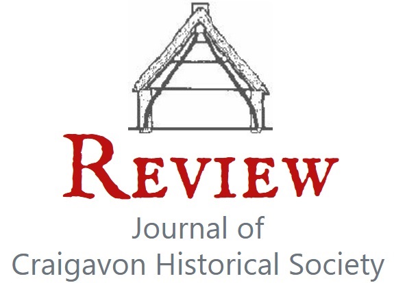
"A" is the Newry canal at walled bridges, the canal and the river.
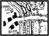
"B" with no walls, perhaps pack-horse jobs, near milestone for Irish miles to Newry and Dublin, and a ford ... these are at the entrance to Library HQ, on the Markethill road out of Armagh, and modern maps label the area "Woodford".
 |
 |
 |
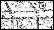
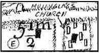
"D" is the Bannfoot ferry on Lough Neagh. "E" represents Mullyglass church with illustrative grave-slabs.
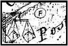
"F" shows the Mall race course finishing post, indicative of handicap racing in Armagh. "H" and "J" appeared on page 38 of the last issue. (1990-1991 Vol. 6 No.2). Note the flapping sails and slack sheets on one ship, and the full taut sails on the other, in the same direction of wind, but sailing in different directions .... one is going about while tacking against the wind.
Poyntzpass, with a lock,11:49 02/01/2019 two shows two half-width bridges Drumintee. "C" has turnpike,
The final illustration is of Lurgan, enlarged to about 3.5" to the mile (Eng). It connects me and my experience with John Rocque's time. The lettering runs from South to North. The straight track between the town and the lake is still there now, with its ends joined by a curved circuit next the lake. A short-cut from near the South end of the straight presently links it to the iron bridge and culvert by the lake corner.
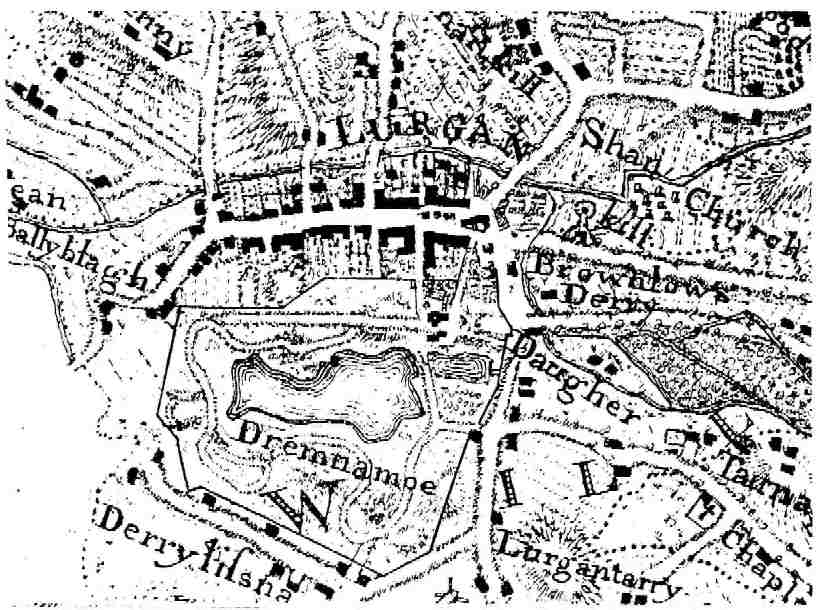
This is the circuit on which we used to race motor bikes about 30 or more years ago. I reached close to 100 mph on part of it then, by no means the fastest recorded by others. If we substitute the steam from sweating horses, and the smell of fresh horse manure, for the acrid tang of burning Ferodo brakes and clutches and the sweet aroma of burning Castrol "R", a vegetable racing oil, we might imagine the younger Brownlows or their supposedly wiser elders racing their horses round the sane circuit, perhaps having the odd spill as well. The smells referred to would have stimulated the adrenalin then as now.
This map of County Armagh must stand as a worthy memorial to John Rocque, who still shows us what our county used to look like, much of what went on in it, and how it related to what we see and do today.
Apart from acknowledging help from the works of the various authors mentioned, I wish to say a special "thank you" to Mr. Roger Weatherup, Curator of the County Museum, and to his charming staff. Also to Mr. Joe Canning and his staff at Library .H.Q.. They were most helpful and patient in extending to me the use of the facilities of their departments, and in assisting in the finding and assembly of much of the data used here.
Mr. Weatherup was also kind enough to plough through the entire first draft of the script with its patches and corrections, spotting 26 instances of slipshod word; or presentation, which I have now tried to make good.
Another "thank you" goes to the owner of the original map for allowing me free access to his treasure, a privilege not taken lightly.
I would add that on a couple of occasions my nerve failed me, and but for the encouragement of two friends and the editor the work would have been abandoned.
My wife patiently worked through sheets of copying and re-copying, with the kind permission of Mr Hector Lester. All in all, this article was by no means a solo effort.